
1
Origins: Indigenous Inhabitants and Landscapes
Oregon is a vast land filled with enchantment, wonder, and promise. Unlike other regions in the continental United States, Oregon hosts a variety of microclimates, terrain, and a variety of flora and fauna that could fill an entire museum. The coastal region offers a majestic and serene back porch to the gigantic and powerful Pacific Ocean surging with potential energy and promise for humankind. To the east of the Coastal Range lies the Willamette Valley and its rich, arable soils nestled between two mountain ranges. On the eastern side of the valley are the Cascade Mountains (known as Yamakiasham Yaina or “mountains of the northern people”), which run through the center of the state into Washington and British Columbia. The Cascades are a series of phantasmal peaks that can be seen on a clear day in the Willamette Valley. Some of the iconic peaks include Mount Hood (known as Wy’east by the Multnomah Tribe) east of Portland, Oregon and the turbulent, crop-topped Mount Saint Helens (known as Lawetlat’la by the Cowlitz people) in southern Washington.
East of the Cascades lies the Columbia Plateau, High Desert, and Blue Mountain regions. The eastern portion of the state is marked by a drier climate in part due to the rain shadow cast by the Cascade Mountains. The northeastern border of the state, adjacent to Idaho, is home to the Wallowa Mountains and Hells Canyon, the deepest river gorge in the United States, and one of the deepest in the world. The Columbia River forms the Columbia River Gorge along the northern border separating the states of Washington and Oregon. The river is named after the ship of the fur trader and explorer Robert Gray, who sailed through the mouth of the mighty river in 1792. The Columbia River is home to various salmon, providing the backbone of life within the biodiverse environment and landscape of the Pacific Northwest.
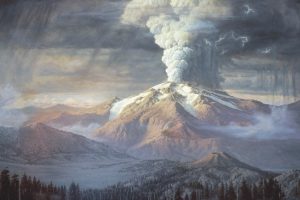
Since Oregon is a mountainous region with active and dormant volcanos, it would be fitting to begin an Oregon story with a significant event in the state’s geological history. Mount Mazama, (known as Giiwas by the Klamath and Modoc peoples) with a peak approximately 12,000 feet high, was part of a complex of active volcanoes. The mountain was destroyed 7,700 years ago by an enormous explosion of molten rock that caused its collapse. The force of the explosion was estimated to have been forty-two times greater than the eruption of Mount Saint Helens in 1980. When the top half of Saint Helens crumbled into Spirit Lake, it completely altered the lake sending a wall of water, rocks and debris into the Columbia River. The eruption of Mount Mazama sent a towering column of pumice and ash thirty miles high into the atmosphere, and when it collapsed, it formed the Crater Lake caldera. The volcanic material settled in thick layers around the outer rim of the caldera, and as the volcanic depression deepened, rain and snowmelt began to fill the caldera. Wizard Island was formed during a separate eruption and stands above the surface of Crater Lake. Indigenous peoples of the Klamath River region recognized Mount Mazama, both before and after its transformation into Crater Lake, as a spiritual center of great power and continue to hold great awe and respect for the mountain.
The Klamath historical memory of Giiwas corresponds closely to geologic data of the cataclysmic eruption. According to one source, the eruption of Mount Mazama was seen as retribution for the people’s violation of taboos, and as punishment for their arrogance and decadence. “They were being punished for forgetting the right way to live,” according to one Klamath.[1] In the wake of the eruption, Crater Lake was seen as a place of potency for visions. The local Klamath, Modoc and Paiute, in addition to Takelma people from the Rogue River Valley, have travelled to the mountain for generations for a variety of cultural and spiritual purposes.
Another significant geologic event that shaped the State of Oregon was the Missoula Flood, or formerly known as the “Spokane Flood.” It was a series of floods that carved out the Columbia Gorge and the Willamette Valley at the end of the Pleistocene Era approximately 13-15 thousand years ago. The ice dams at the Clark Fork River periodically ruptured releasing a torrent of flood waters with an estimated force of ten times the combined hydropower in all the world’s rivers. The water carried rocks and other debris barreling down the Spokane River Valley, westward through the Columbia River Gorge, carving out the Grand Coulee and the Channeled Scablands of Eastern Washington, and spilling into the Willamette Valley and the Pacific Ocean. After each release of water, ice would rebuild on the glacial Lake Missoula. Like an overflowing tub, the water pooled in the glacial lake increasing to about twice the size of the state Rhode Island, only to repeat the process again over time. As a result of the Missoula Flood, large boulders and alluvial silt were deposited into Willamette Valley forming fertile agricultural lands. About 6,000 years ago, humans descended from the surrounding hills into the Willamette Valley when the floor became dry enough. Today, hikers and nature enthusiasts can learn about this event along the Columbia River Gorge in places like Beacon Rock, Washington.
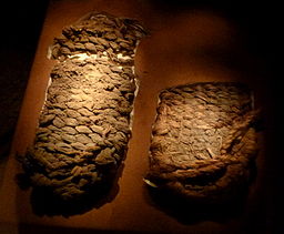
In 1938, University of Oregon archaeologist Luther Cressman discovered dozens of sandals below a layer of volcanic ash from the eruption of Mount Mazama at Fort Rock Basin of Central Oregon. The sandals were constructed from sagebrush bark and date from 10,400 to 9,100 years ago, making them among the oldest footwear ever found. Archaeological excavations have taken place at Paisley Caves in southern Oregon since the 1930s. Stone projectile points, baskets, rope, wooden artifacts, and animal bones found in the caves date back to at least 13,200 years ago, predating artifacts from the famous Clovis culture, first documented in New Mexico, by more than one thousand years. Scientists have concluded that Paisley Caves, 220 miles southeast of Eugene on the eastern side of the Cascades, were an ancient stopping place for trade among indigenous peoples.
Newer theories have emerged on human migration into the American continent that brought the original inhabitants into Oregon. The Bering Land Bridge theory became the orthodox view among archaeologists as the primary explanation for human migration into the Americas. But according to Cressman and other scientists’ findings, the Bering Land Bridge theory doesn’t account for the presence of people in North America 13 thousand years ago. Other theories surmised that seagoing people travelled along a “kelp highway” from Asia, and went east along the Bering Strait, and then southward along the northwest coast to California. Kelp highways, and coastal areas in general, provide a diversity of aquatic mammals, fish, shellfish, and plants for travelers who came from the Asian continent. According to several indigenous people, including Little Turtle of the Miami tribe, they have concluded people originated on North American soil, and did not arrive from the Eurasian continent.
Ancient indigenous cultures have lived near Celilo Falls, known as Wy-am, along the Columbia River in what is known today as The Dalles. It was one the oldest occupied zones on the continent. The ancient fishing ground of Celilo Falls along the Columbia River, called Nch’I Wana (“The Big River”), produced a bonanza harvest due to an estimated six to ten million fish that returned to spawn in the Columbia River. Archeologists found that Indians, including the Chinookans, Wascos, Klickitats, and Sahaptins have been fishing in the area for at least 11,000 years, and was one of the greatest fisheries in the area for millennia.
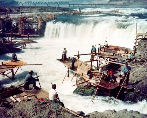
The salmon runs created a vital trade center in the region. Various indigenous groups brought goods to the region from Yellowstone and the Great Basin covering several western states. Salmon pemmican has a long shelf-life, making the fish more durable and portable. The salmon runs helped make The Dalles the greatest trade center of the north Pacific slope. Traditionally, the waters of the Columbia united rather than divided human populations, and interdependence formed a common bond among communities. Men and women of Celilo Falls worked together to harvest and process the salmon. Fishing stations became sites of social and ceremonial activity. Rituals were incorporated into the salmon runs, and fishing season would not start until the ceremonies were over. As a ritual act, salmon bones were thrown back into the water to allow the salmon spirits to return to the sea. As it turns out, this practice provided nitrogen replenishment for the riparian ecosystems of the Columbia River. Those who lived closest to the Columbia riverine system were known in the Sahaptian language as “people of the river.” Fishing rights secured more than just food sources; they were a central part of their cultural and religious practices and their identity as a distinct social group. A system of reciprocity between cultural groups kept a relative peace and security to the area.
Further south, in the Great Basin, the Northern Paiute lived a nomadic lifestyle following animals and other seasonal food sources. The names of each band was named after a food source; therefore, the people of Carson Sink were known as “Toi Ticutta” meaning “tule eaters.” Unlike other indigenous tribes of the Northwest like the Nootka, few if any internal social distinctions existed among the Northern Paiute; people did not accumulate wealth which would have enabled them to command the labor of others. The homeland of the northern Paiute is dry with low amounts of rainfall. Northern Paiute people remained in small bands, like other Indian groups of the Great Basin, because access to water sources was limited. They did not practice large scale agriculture, but had extensive and sophisticated irrigation ditches. They used sticks to unearth roots, and were referred to as “digger Indians” in a derogatory manner by white colonialists. At the confluence of the Snake and Boise Rivers, they met with other indigenous groups to trade and communally fish. Items processed and manufactured by these people were traded as far north as Alaska and east to Missouri.
Northwest Coast peoples maintained densely populated societies without the benefit of agriculture. Their most important resource was salmon. Scholars estimate that the average resident along the lower Columbia or the coast ate about 365 pounds of salmon a year. Access to food allowed more time for social activities and rituals, including potlatches, where surpluses of food were redistributed by the chief to all members of society and for trade. The Chinook and Coastal Salish populations reached densities of 400 people per 100 square miles. Unlike the tribes in eastern Oregon, there were social distinctions among these groups—a wealthy man could have many wives and even slaves. They were status-conscious residents, whereas desert plateau society was egalitarian since distinctions of wealth were less concentrated.
From an ecological perspective, the Willamette Valley environment provided more abundant food sources than the desert-like Columbia Plateau or the Great Basin east of the Cascades. Willamette Valley populations had social organization practices similar to the desert regions of eastern Oregon. Social relations were mostly egalitarian and slavery was a foreign concept. Before European American settlement, the Willamette Valley’s landscape had a different appearance. The indigenous peoples used fire in the valley and encouraged the vigorous growth of tall grasses, such as meadow barley, acorns and bluegrass. These long grasses were collectively referred to as kalapuya by the indigenous population, and so when the European Americans encountered these peoples, they referred to them collectively as the Kalapuya. The Tualatin-Yamhill Kalapuya occupied the northern Willamette Valley, the Yoncalla lived in the south in the Umpqua region, and the Santiam inhabited the greater portion of the central and southern Willamette Valley. The Kalapuya subsisted primarily on plant foods, less so on game and fish. They had a less varied diet than the Chinook of the Columbia River and the Coastal Salish of Puget Sound. The Kalapuya relied on camas, a large, seasonally abundant tuber, as a staple of their diet and set fire to the valley grasses to encourage its growth. Camas is a member of the lily family, and the nutritious elements could be found in the edible bulbs that were mashed into a paste for breads. By burning the valley floor, the Kalapuya altered the environment to create more open meadows where camas thrives, and prevented the growth of contiguous pine forests. Acorns also came widely into harvest and production, which was a staple food for the Kalapuya as it was for the Chumash Indians of south-central California. These grass fires had little effect on the California black oak trees that grew in Oregon. By keeping the ground clear of other trees, the oaks were able to produce large amounts of acorns. The Kalapuya also cleared the land to grow tobacco, which was their only cultivated crop in the modern sense.
The original inhabitants or indigenous people of Oregon comprise of various tribes and groups representing a rich cultural diversity. The landscape of the region was shaped by their cultural footprint and their societies held property as communal or belonging to the tribe. When the indigenous people of Oregon encountered European explorers in search of commerce and land, their cultures and societies entered a gradual upheaval that occurred in stages. The beginnings of the cultural encounter and exchange between Euro-Americans and Natives was prefaced by the fur trade and Western nations seeking empires for trade, colonial possessions, power and prestige. The Euro-American culture represented a different set of values and beliefs that conflicted with previously held customs and institutions of indigenous people. European Americans came to the Pacific Northwest with perceptions and beliefs about Native Americans from earlier experience. The explorers and fur trade opportunists bore an imperial hubris and carried assumptions of their cultural superiority over the indigenous people of Oregon. The next chapter will examine these encounters and how Euro-Americans became enchanted with the Oregon region during the fur trade, and how they influenced the Native American communities of Oregon.
[1] Douglas Deur, “A Most Sacred Place: The Significance of Crater Lake among the Indians of Southern Oregon,” Oregon Historical Quarterly, Vol. 103, No. 1, (Spring, 2002), pp. 18-49.
