
8 Expedition of Bruno de Heceta
The Viceroy should have rejoiced at the ratification of what really mattered to him and the Spanish king, which was confirmation that no other European nations had settlements in the Northern Pacific coasts beyond the garrison and port of San Carlos Borromeo de Monterrey. After Pérez Hernández’s expedition there remained no doubt, neither for the expeditionaries nor for the Viceroy, that the only inhabitants of those coasts, at least until 55 degrees of latitude, were the Natives of those territories.
Nevertheless, Viceroy Bucareli wanted to fulfill one of the requirements of any exploration trip, one not achieved in the Pérez Hernández expedition. This was, of course, claiming possession of territories previously unknown to Europe on behalf of the King. Therefore, he organized a second trip. He also relied on the participation of Pérez Hernández (for whom this would be the last expedition of his life). Only a few months after the ships under his command had returned to the port of San Blas, a new expedition set sail to the north.
On this occasion, the order of the Viceroy Bucareli was that the frigate Santiago would be commanded by the ship lieutenant Bruno de Heceta (or Ezeta), because he was the oldest and because he had requested it in order to increase his worth. Juan Pérez would go as his first official, as well as first pilot and práctico.[1] They would also go with the same crew that had just arrived, replacing those who were not fit to sail again.
The instructions would be the same in principle as those carried by Pérez Hernández, as they were “commisioning very particularly that greater altitude be taken” but, on this occasion the expeditionaries were to take possession of all the lands discovered and map the coast from Monterrey to the North.[2] In addition to Pérez Hernández, Juan Francisco de la Bodega y Quadra from Lima would also accompany Heceta on this trip. Regarding the development of this new expedition and its results there exist different and interesting documents, including Heceta’s navigation diary;[3] the diary of Francisco Antonio Maurelle, the second pilot of the schooner Sonora;[4] the diary of Juan Manuel de Ayala aboard the San Carlos packet boat (alias the Toisón de Oro);[5] and the diary of friar Miguel de la Campa, chaplain of the frigate Santiago;[6] as well as the testimonies of possession of the port of La Trinidad, the Rada Bucareli, the port Bucareli, and the port of Los Remedios[7] as well as all the plans and maps that resulted from this trip.[8]
In mid-March 1775, the expedition departed from the port of San Blas to the North with about 160 men on board (most of them from New Spain) and provisions for a year. According to Heceta’s diary, it was not until June 9th that they saw the first natives, probably Yurok, “naked and with their hair untied”, who approached them in canoes and exchanged pelts with the sailors.[9] That same day they managed to anchor both the frigate and the schooner, and, the following day, the expedition members went ashore to take possession of what they would call the port of La Trinidad (near Eureka) and, since it was the day of the Holy Trinity, celebrated Mass. They were at a latitude of 41 degrees and 7 minutes, halfway between Cape Mendocino and Cape Blanco. They stayed there for several days, establishing a good relationship with the natives both on the beach and in the vicinity. On the 14th, when they took attendance they noticed that two cabin boys were missing, José Antonio Rodríguez and Pedro Lorenzo, who after having voluntarily stayed with the Natives returned several days later to the frigate.
On the 18th the map of the port was already finished and they went to explore a nearby river that they called Tórtolas (present-day Little River in Humboldt County). The expedition members remained there until June 19th, so Heceta had time to observe the Natives, and wrote a note in his journal about them, observing that:
(…) they were of medium size, robustness and agility, without beauty in either sex; brunette color, long and straight hair, black and happy eyes, with no beard. The men do not wear any clothing, not even to hide the most dishonest parts, and only when the cold forces them they cover themselves with well-dressed skins of deer, cíbolo,[10] pronghorns, bears, otters and a kind of blanket woven from rabbit skin and others (…); women cover themselves from the waist to the knees with a sheepskin or grass skirts, which some end in different threads such as fringe and in others it begins and ends like this (…) this sex likes beads, but they do not have much appreciation for cloth and fabrics (…). These Indians are mild-tempered, docile, and timid. They love, distinguish and obey the eldest, who governs with his advice, and, to my knowledge, each village is made up of only their offspring ( …). Iron is the metal that they value the most because they know its advantages in the use of weapons. The ones they use are the arrow, spear, knife or dagger, whose tips and edges are well-worked flint. They also make use of iron knives, which are usually carried around their necks by means of a cord, holding them in their hands when they distrust. With extreme curiosity, I inquired several times where or with whom they had exchanged those irons. All unanimously responded by pointing to the coast to the North, except for one, who had carved his own with a nail that was caught in the fragment of a boat that the sea had thrown onto the beach. When they go to war or deal with enemies they paint their faces or bodies in black and other colors, believing, without a doubt, that it makes them more horrible and fearsome.[11]
Heceta also collected data on the flora of the area and highlighted in his journal the existence of the oregano plant in those territories: “the plants that I was able to find are: oregano, celery, strawberries, peppermint, chamomile, lilies and roses of Castile.”[12]
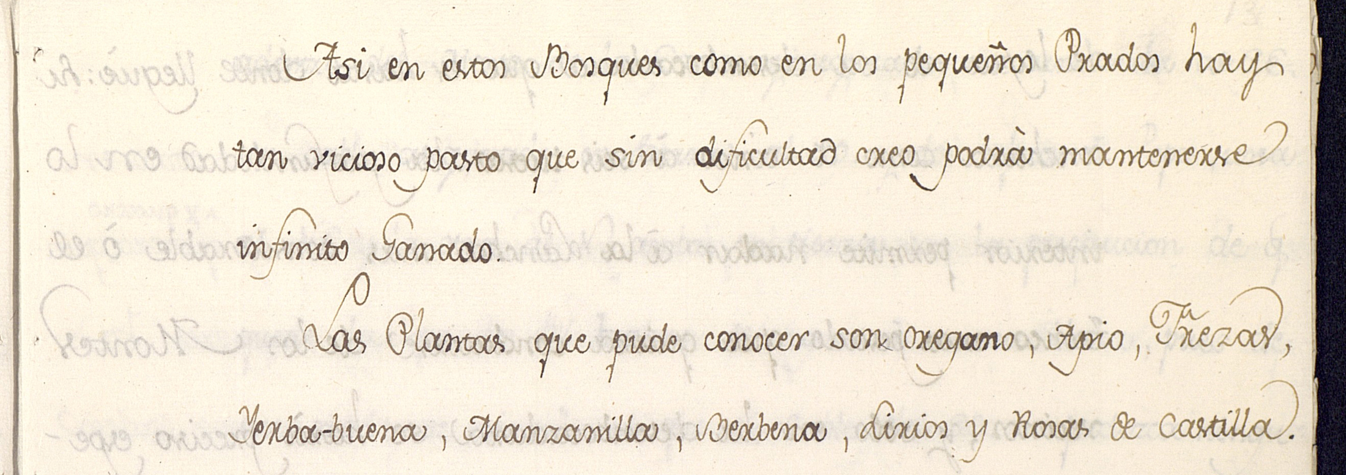
FIGURE 6. Copia del Diario de navegación que hizo el Teniente de navío Don Bruno de Hezeta en la fragata Santiago, alias la Nueva Galicia, que fue a los descubrimientos de las costas septentrionales de California desde el Departamento de San Blas, del 16 de Marzo a 20 de Noviembre de 1775. [First reference to the existence of the oregano plant in Heceta’s diary].[13]
the yurok
The natives that Heceta observed were certainly the Yurok, and the village to which the two cabin boys went was Tsurai (Chue-rey). The Yurok, whose name comes from the word karut, or ‘downstream,’ were established along the Pacific coast and the Klamath River, from Damnation Creek north to the south of Little River, with villages located along the coast and the river. Traditionally, the Yurok people that lived in the upper region of the Klamath River were pe-cheek-lah, those that lived in the inferior region puelik-lah, and those on the coast ner-er-ner. All of them spoke a macro-Algonquian language and were culturally and linguistically related to the Wiyot. Their neighbors were the Tolowa in the north, the Wiyot in the south, and the Karuk in the east. As their traditional territory was on the border between distinct cultural and ecological areas, the Yurok combined the typical subsistence practices of the Northwest Coast with many religious and organizational characteristics common to the California native population.
Traditional Yurok villages were small nuclei of independent houses built from redwood, each owned by different families, thus avoiding unified communities and a general political authority. The families or houses within the villages possessed rights to specific resource-gathering areas, such as fishing grounds, acorn-gathering sites, and hunting areas; these rights appear to have been acquired by inheritance or by dowry. The residents of each village sometimes shared the rights to subsistence areas and also the performance of certain rituals. In the river, they gathered salmon, sturgeon, eels, and other fish and at the coast, mussels, clams and other species. They also hunted deer, elk, and smaller animals, and in the fields near the mountains they gathered acorns and other fruits. They produced excellent basketry and also made canoes from redwood trees that they sold to the inland tribes.
On June 19th, Heceta’s ships left the Port of La Trinidad. The next day, they anchored at a nearby beach, and a day later they continued their navigation until July 14th, when Heceta returned to land at 47 degrees and 24 minutes to baptize the cove as the Rada de Bucareli (current Bay of Grenville, on the border between Washington State and Canada) in honor of the Mexican Viceroy. The schooner was forced to anchor a little further away due to the presence of some shoals and it did so downwind of what is now Cape Elizabeth, south of the mouth of the Quinault River. In the Rada de Bucareli, Heceta also had contact with the Natives, although only six appeared on land, without weapons, with whom they exchanged fish for beads. Later he saw nine other Natives who approached the frigate. These “had a beautiful face, some blond and others dark, all corpulent, well made. Their clothing was made up of otter skins, with which they are covered from the waist up.”[14] The expedition members of the frigate did not socialize with them. Before leaving, however, Heceta observed that the schooner was having difficulties sailing and showed signs of distress, so he sent a boat to help. On its return they brought him a letter from the commander in which he told Heceta that when seven of his men went for water ashore they were surrounded by three hundred or more Natives, who had killed five of them, and of the remaining two nothing was known. Despite this account, Heceta decided to set sail and did not act against the Natives for various reasons, fundamentally because the instructions of his trip established that they could only attack the Natives to defend themselves. Before leaving, they decided to name the place where the fatal encounter took place as Punta de los Mártires (current Point Grenville), in memory of the deceased.
The Quinault and the Quileute
The explorers could not then know that they had entered waters disputed at that time by two conflicting nations, the Quinault and the Quileute, both neighbors to the south of the Makahs. According to Joshua L. Reid in his work The Sea is my Country: The Maritime World of the Makahs, the peaceful attitude of some (the Quileute) and the aggressive reaction of the others (the Quinault) indicates that they were two different tribes, as recorded in the oral histories of the Quinault.[15] Those who approached the schooner Sonora bringing whale meat and fish must have been Quileute, since they enjoyed better access to whale meat, something that would have been quite unlikely on the part of the Quinault, since they only got whale meat occasionally. When some of the crew from the Sonora landed, they did so at the mouth of the Quinault River, located in the Quinault territory and near Taholah, one of its villages. Surely, when the Quileute’s canoes returned after the Quinault ambush, they had armed themselves to fight the Quinault, not to attack the schooner.
The position of the Spanish ship suggests that the Quileute had entered the waters of the Quinault, thus threatening their control over that space, and the Quileute surely armed themselves in an attempt to ally themselves with the Spanish against their rivals. The explorers, for their part, were trying to acquire new geographical spaces for the Crown. They claimed possession by planting a cross on the ground, an action that some Quinault may have seen from the safety of the forest that hid them. Either way, the fact that the Quinault attacked the men of the schooner could perhaps be due to the fact that they resented the explorers taking water and wood from their rivers and forests. It could also have been to punish them for having traded within its waters with their rivals, the Quileute.
The Quinault who faced the expeditionaries were natives named after their largest settlement, Kwi’nail, now Taholah, located at the mouth of the Quinault River. Their original territory extended upriver to Lake Quinault and along the Pacific coast from the mouth of the Raft River to Joe Creek, near the beach called Pacific. They were one of the coastal society sites of the Olympic peninsula in Washington State. These societies included, from the north all the way to the south: the Makah (on the Flattery Cape), the Ozette, the Quileute, the Hoh’s, the Queets (similar to the Quinault in language and manners), the Quinault, the Copalis-Oyhut, the Chehalis, the Shoalwater Salish, the Willapah, and the Chinook in the Columbia estuary. All of them were relatively small societies, interrelated by trade, matrimonies, and conflict. Their customs were very similar to the other tribes of the Northwest Coast culture, such as the Haida, the Nootka, and the Kwakiutl. Like the rest of their neighbors, they were hunter-fishermen and they fed on the resources offered by the sea and the forests that surrounded them, from which they obtained wood logs for their canoes, boards for the construction of their houses, and bark chips with which to make some clothing and utensils. Their language is considered as part of the Salish family.
For their part, The Quileute (Kwi li Ut or Quillayute) had also inhabited for thousands of years part of the territory of current Washington State, extending along the Pacific from the glaciers of Mount Olympus. Their language belongs to the Chimakuan family and is one of the five languages known to have no nasal sounds (that is, neither m nor n). Like other tribes in the region, their food depended on fishing from the rivers and the Pacific Ocean, for which reason they were excellent builders of boats and canoes. Their canoes were large and were used for whaling; together with their neighbors, the Makah, they were great whalers. They also built houses from planks to protect themselves from the cold weather coming from the Cascade Mountains. They were famous for their fine woven baskets and blankets, as well as utensils and even clothing, that they made from the bark and wood of the cedars of the surrounding forests.
Continuation of the Heceta Expedition
From July 14th to July 19th the Heceta expedition had calm winds. Then, Pérez Hernández informed the crew of the high number of sick crew on board and of the difficulty of continuing to sail further north. For this reason, on the 24th, the rest of the officers supported Pérez Hernández’ decision to return. On the 30th the frigate Santiago lost sight of the schooner, but it continued sailing and reached 50 degrees and 40 minutes.
However, on August 11th the Heceta party began the return trip because a large part of the crew was ill. A day later, at a latitude of 49 degrees, four native canoes approached the ship, and with whom they exchanged some otter pelts, being able to observe that their countenance and clothes were very similar to those of La Trinidad. These natives were probably the Hoh Indians, a tribe that shares language and customs with the Quileute and the Quinault. They lived along the sides of the Hoh River, the name of which seems they received from the Quinault, though those who spoke Quileute called it Cha’lak’at’sit, River of the South. They called themselves Chalá-at or Chalat, People of the River of the South. They lived in settlements along the banks of the Hoh River on the Olympic Peninsula, where they set traps to catch fish that crossed the river. They also went up the river with their canoes to hunt, gather fruits and wood, and perform their ceremonies and rituals.
Heceta’s men continued south, and at 47 degrees and 58 minutes they saw an island which, in memory of the expedition members killed by the natives, they named Dolores. A few years later, the English would rename Dolores the Island of Destruction, also due to a confrontation they had with the Hoh, who used to frequent the island to capture birds. That same afternoon the natives approached Heceta’s men with sardines and pelts to exchange. Some of the crew members said that two of the Natives were among those who had approached the ship in the Rada Bucareli on July 14th, and as such had been accomplices in the betrayal that befell the schooner. Heceta tried to communicate with the Natives to gather information about the two sailors who had disappeared, but he failed to communicate with them and continued his navigation.
They unknowingly passed the Strait of Juan de Fuca, and, during the evening on the 16th (at 46 degrees), they discovered a large bay which they named Asunción. Strong winds prevented Heceta’s party from anchoring in Asunción and led them to believe that they were near a great river or possible passage to the sea. Though the party never reached land, they did create a map of the bay and its two capes, named Frondoso and San Roque (now Cape Disappointment and Cape Adams), where the Columbia River estuary (also called Entrada de Heceta and San Roque River) can be distinguished. This map would be the first one composed by Hispanic expeditionaries in which the coast of Oregon is explicitly depicted, or at least appears to be the first one preserved in Hispanic archives.
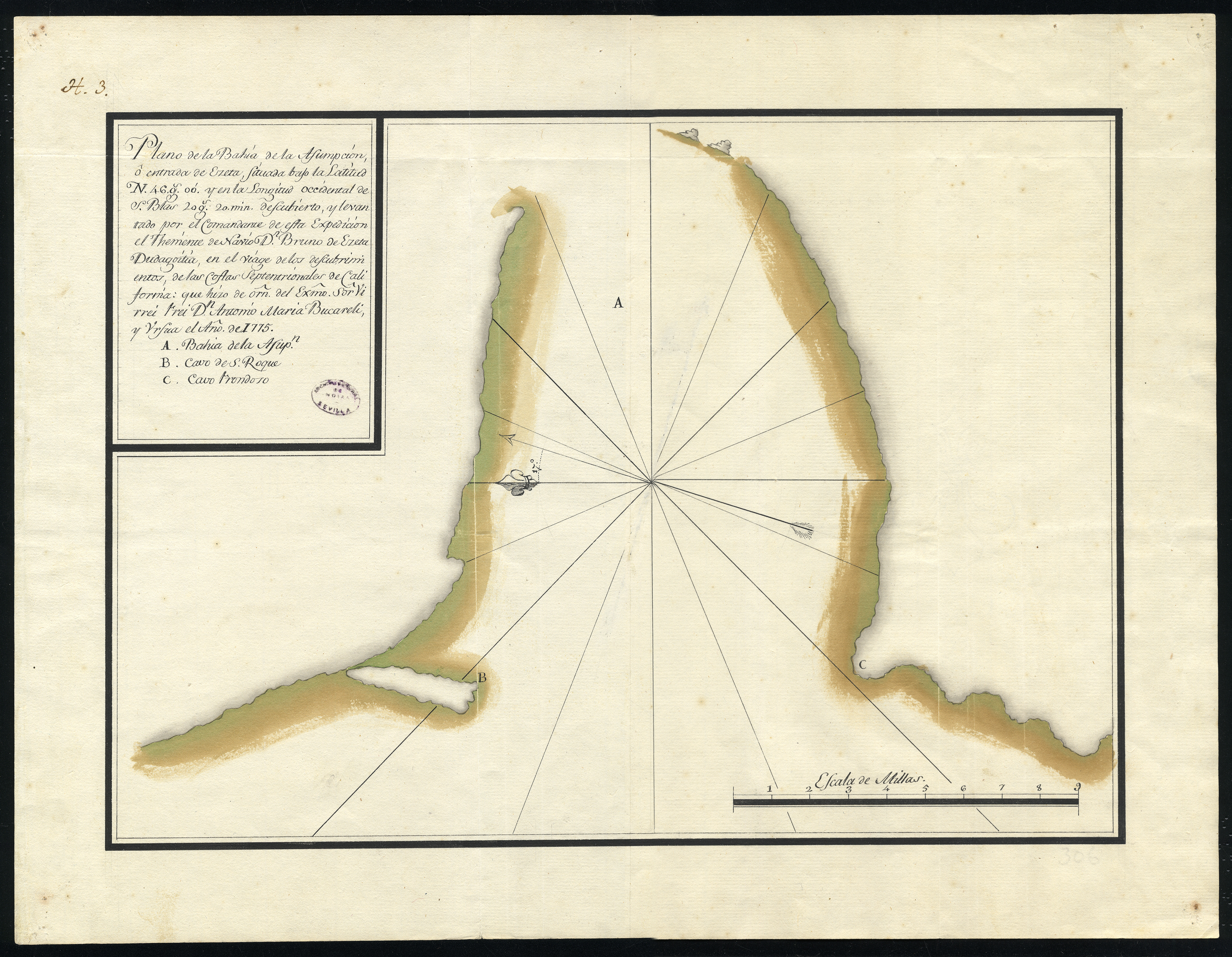
FIGURE 7. Plano de la bahía de la Asunción, o entrada de Heceta, entre los cabos San Roque y Frondoso, en la costa del Pacífico noroeste, correspondiente a la expedición de reconocimiento hecha en 1775 por el teniente de navío Bruno de Heceta y Dudagoitia, por orden de Antonio María de Bucareli y Ursúa, virrey de Nueva España, 1775. [First map created by Hispanic expeditionaries on which the coast of the current state of Oregon explicitly appears. The Bay is represented with the letter A, in the estuary of the Columbia River, which opens between Cabo San Roque (current Cape Disappointment), represented by the letter B, and Cabo Frondoso (current Point Adams or Tillamook Head) with the letter C].[16]
Heceta’s men continued navigating. At a latitude of 45 degrees and 58 minutes they found a cape that they baptized as Diligencia. Later, at 45 degrees and 28 minutes, Heceta named the Cabo Falcón (on the coast of present-day Tillamook) and named a flat mountain Mesa (which would later be named Clark’s Point of View by Lewis and Clark). At 45 degrees and 30 minutes they observed three cliffs and named them LasTres Marías (surely the current Three Arch Rocks in the cape that Vancouver named Lookout). Upon reaching the latitude of 42 degrees and 30 minutes, experts aboard the frigate demarcated the Cabo Blanco de San Sebastián, and by observation of the sun Heceta established that it was located at 42 degrees and 10 minutes. On the 26th they arrived at Cape Mendocino, which they situated at 40 degrees and 7 minutes; on August 29th they arrived at the port of Monterrey, with a large part of the crew ill, and finally arrived at the port of San Blas on November 20th.
Observations of Friar Miguel de la Campa
Fray Miguel de la Campa also reported in his journal about Heceta’s meeting with the Natives on June 9th at the site of Trinidad, including the visits they made to their village. The natives planted tobacco plants and De la Campa took note of the Natives’ love for smoking their pipes. He also observed that:
(…) men are completely naked and only use suede deer skins with the fur facing inside for greater warmth. Women cover themselves with the same and they also make a sort of petticoat of the same material, which they adorn with palm works, and at the bottom they leave them a lot of very thin strips as fringes, and in the front some aprons made of reeds . Women also paint their chins with three black stripes, which makes them ugly. Men adorn their arms with paintings. They all wear long hair, except young men and young women who wear it short, which distinguishes those who are not married.[17]
Friar Miguel de la Campa also noted the native’s friendly nature: they helped collect water and firewood, and ate together with De la Campa on the beach. He also gathered some information about the flora, writing that the land was “(…) full of grass and many herbs and flowers, rose of the Castile, lilies, chamomile and spearmint, celery, pennyroyal, oregano, verbena and other scented herbs that the Indians eat, who also gave us blackberries (…).”[18]
Regarding the second time that they went ashore to take possession of the land, at the Rada Bucareli on July 14th, the priest fell upon the falsehood of the Natives, because, he observed, while they were kind and friendly with them, they planned the attack on the sailors who descended from the schooner to land, ripping five of them to pieces and disappearing two more in the water. Fray Miguel collected in his journal that these natives:
(…) were white, with blonde hair and of good height. They use bows and arrows and they have flints in the shape of a rejón that they put on long sticks like those used in a spear. They use some types of styled leathers, as white as the leathers that the soldiers have in the presidios, the ones with narrow sleeves, which cover them down to the knees, on which they paint the skulls of those that perhaps have been the spoils of their treachery, and they put them as trophies of their bravery. Women wear petticoats like the ones I already said from the area of the Port of Trinidad, and pierce their noses, and put a ring on them. Like the one worn by those who were aboard the schooner which the captain told me that he thought was made of copper. The men are naked and for the cold they use leathers of otter or deer suede to cover themselves. They make many holes in their ears and from there they hang many small shells of various colors.[19]
De la Campa also mentioned in his journal how he perceived the natives from the schooner prior to their attack: “it even seemed like they were carrying human parts of the people and the pieces of the canoe in which they had gone to get water (…).”[20] Therefore, they were suspicious when they approached the bow, so four sailors faced them (the Indians) with a small cannon and three rifles, killing at least six of the Natives, while in the frigate nothing was known because it was a league away.
Sailing back on August 13th, at a latitude of 49 degrees and 5 minutes, the Heceta party once again saw several natives in their canoes, with whom they exchanged fish and a canoe for a saber. Of these people the friar noted that:
They used, to cover themselves, clothing made out of hemp. With something like an apron, they cover themselves from their waist down, and for the chest they make it smaller with fringe on the bottom part, and while wearing it it has the figure of a short cape. They wear hats made out of palm, some of them have the shape of a mortar and others look like doctor’s tassels. They have bone harpoons for fishing. Besides bow and arrows, they use bone spears, because with a sailor they exchanged a harpoon and a spear.[21]
On June 11th, at the latitude of the mountain range that the previous expedition had named Santa Clara, the Heceta party once again spotted a canoe of natives which the sailors said had killed those of the schooner. They tried to capture them to see if they could find out something about the two men who disappeared, but failed because the Natives fled. The Heceta party continued sailing back to the bay they had named Asunción Bay (which was in reality the mouth of the Columbia River, but they did not recognize it) naming the high mountains nearby as Montefalco, for having discovered them on the day of Santa Clara de Montefalco. They arrived at Cape Mendocino and then to Monterrey on August 29th, with thirty-six sailors suffering from scurvy and many others from different ailments, “which together amounted to fifty sickened out of the ninety-two members of the crew.”
A few days later, the schooner, which had become separated from the rest of the small fleet on July 31st, arrived at the Port of Monterrey, and friar Miguel de la Campa recorded in his journal the news received from Juan Francisco de la Bodega y Quadra. The schooner reached a latitude of 57 degrees and 18 minutes “and in a port they called De los Remedios they claimed possession of the land and collected water and firewood (…). They noticed that the Indians were of black color and ugly, that they did not use arrows but a spear that they handled with great dexterity.”[22] These must have been Tlingit natives indicating the expeditionaries were probably near what is now Sitka.
On August 21st the Heceta party continued their navigation, but the next day, at 58 degrees, the cold was so excessive that they resolved to return along the coast. They reached 55 degrees and 17 minutes and found a large canal and good beaches to anchor, so that on the 24th they took possession and gave the place the name of Entrada de Bucareli. They gathered water and firewood, and thanks to the good weather the seamen were able to fortify themselves. On the 26th they went out to claim an island and named it San Carlos (currently Forrester Island), and a nearby cape they called San Agustín (currently Cape Muzon). With the crew somewhat recovered, the expedition continued sailing north, reaching a height of 65 degrees and 40 minutes, where the winds prevented further navigation and forced them to backtrack to Monterrey, where they finally anchored on October 7th. Francisco de la Bodega y Quadra also told friar Miguel de la Campa that it was when leaving the port of Monterrey, on the way to San Blas, on November 2nd, when the second captain Juan Pérez Hernández died. He was given a maritime burial with rifle and cannon salute.
Francisco Antonio Maurelle’s Writings of Port Trinidad
Francisco Antonio Maurelle, the second pilot of the schooner Sonora, also wrote a journal during the expedition. In it, he chronicled that in the Port of Trinidad, at 41 degrees and 7 minutes, more than three hundred natives came to the beach. During their stay, the expeditionaries “took care to observe the movements of the Indians, their way of life, their dwellings, dressing, dominions, the rites of their law, language, weapons of their use, that to which they were most interested in, their hunting and fishing;”[23] he noticed that “in the lids of the ears they wear two screws similar to those in the butt of a rifle.” As for the women, the pilot noted in his journal that “they use the same bone screws in their ears that men put on.” Of the flora, Maurelle described:
The land was flooded with wild herbs, like the European meadows, with a green smell that made the sight and smell pleasant; there were roses of Castile, oregano, lilies, celery, thistle, chamomile, and other common herbs of the countryside. We also saw strawberries, blueberries, blackberries, sweet onions, and small potatoes from the land, all in moderate abundance, particularly in the vicinity of rivers. Among the herbs we observed one similar to parsley, although without odor, that the Indians crushed with a bison pestle to mix it and ate.[24]
While in the Port of Trinidad, Maurelle described a disagreement between the Natives and Sonora crew members. He wrote that they were about halfway away from the frigate, in a shallow area, so they decided to wait for high tide to get out of there. At first the natives approached them to offer them fish and meat, and later they left for their village; the next day they got closer again and exchanged some animal pelts. Seven sailors of the crew, convinced of the friendly character of the Indians, launched a canoe into the sea to go to the beach to get water and firewood near the river. Once there they encountered about three hundred Indians who attacked them and ended up killing five of the sailors, while two others managed to jump into the water. Then from the schooner, they shot their small cannons and rifles to scare the Natives, and they also made signs to those on the frigate to warn of the danger they were in, but they did not see them. They could do nothing, only wait for the Natives to retire. The seven men of the crew were not seen again, nor did they see the canoe. The Natives approached them again the next day with the clear intention of attacking them, but the expedition crew fired their rifles and managed to drive them away. Shortly after they met with the frigate and in a meeting, they discussed whether they should respond to the attack or not; ultimately, the officers decided to withdraw and continue navigating.
Last Stages of the Heceta expedition
Maurelle also recorded in detail the navigation they made since they lost sight of the frigate on August 1st and they continued heading north. On the 17th, at 57 degrees and 2 minutes, they sighted a snow-covered summit from which wide channels came out, which they called San Jacinto (present day Mount Edgecumbe), they also baptized a nearby cape as Cabo del Engaño. They were at the southwestern tip of Kruzof Island (in the archipelago called Chichagof by Russians and Alexander by the British. About three leagues from there, along the northern part of the cape, they found a good port to anchor, which they named Guadalupe. De la Bodega named that cove Del Susto (later it would be named Norfolk by James Cook, and Tchinkitane Bay by Fleurieu in his 1801 map, in an attempt to use Tlingit place names; it is the current Strait of Sitka). There they saw Natives again in their canoes, but they had no contact with them, and they continued sailing to a port they named Los Remedios (currently Salisbury Cove or Sea Lion Bay) at 57 degrees and 18 minutes. There, they descended ashore to take possession of it, following all the requirements provided in the instructions given by the viceroy of New Spain. They met Natives there as well, but they did not have any dealings with them, although they could observe that they did not use arrows like those they had seen until then, but they did use spears that they handled with great dexterity. This means that they were likely Tlingit, since their offensive armament was basically composed of short spears and harpoons. The crew remained there until the 21st when they set sail, and a day later they were at a latitude of 58 degrees. From there they began to go south until they anchored at a latitude of 55 degrees and 17 minutes in a port they called De Bucareli, in which they also took possession and obtained water and firewood. From there they went to the island named San Carlos and to the Cape of San Agustín.
On the 27th they set sail, and for a few days they tried to recognize the great entrance that was lost on the horizon, believing that it was the mouth of a great river (currently the Dixon Entrance). But there were so many sick crew on board, along with the rough seas and the strong winds, that they then decided to return immediately to the Port of Monterrey. On the way back, when they were at 55 degrees, they suffered a storm that almost capsized them. At the latitude of 49 degrees they began to approach the coast again, with the intention of looking for the famous Martín Aguilar River, which they did not find, and from 47 degrees and 30 minutes they began its reconnaissance, and so they went south in search of the Port of San Francisco. On October 3rd, at 38 degrees and 18 minutes, they entered a cove, after having rounded a point that they called Del Cordón (now Punta Sand). In another nearby point, which was named De las Arenas, they anchored, calling the said port De la Bodega, where they again had contact with the Natives and exchanged gifts.[25]
On the 4th of October the men of Juan Francisco de la Bodega set sail, and on the 6th they reached the port of San Francisco, from where they sailed to Monterrey. They arrived with so many sick sailors that Heceta had to send a new crew from his people to be able to continue to the port of San Blas. Everything that happened in this expedition was reported to the Spanish Court by Viceroy Bucareli, pointing out the fundamental results of the trip. Firstly, Spanish dominions became recognized and indicated in almost 500 more leagues than what had previously been navigated until then. Secondly, they obtained knowledge of the native populations of these coasts and confirmed the nonexistence of foreign establishments. Finally, maps were elaborated to allow better trips, as there were still some legends or geographical interpretations of mythical nature that had not been totally discarded yet.[26]
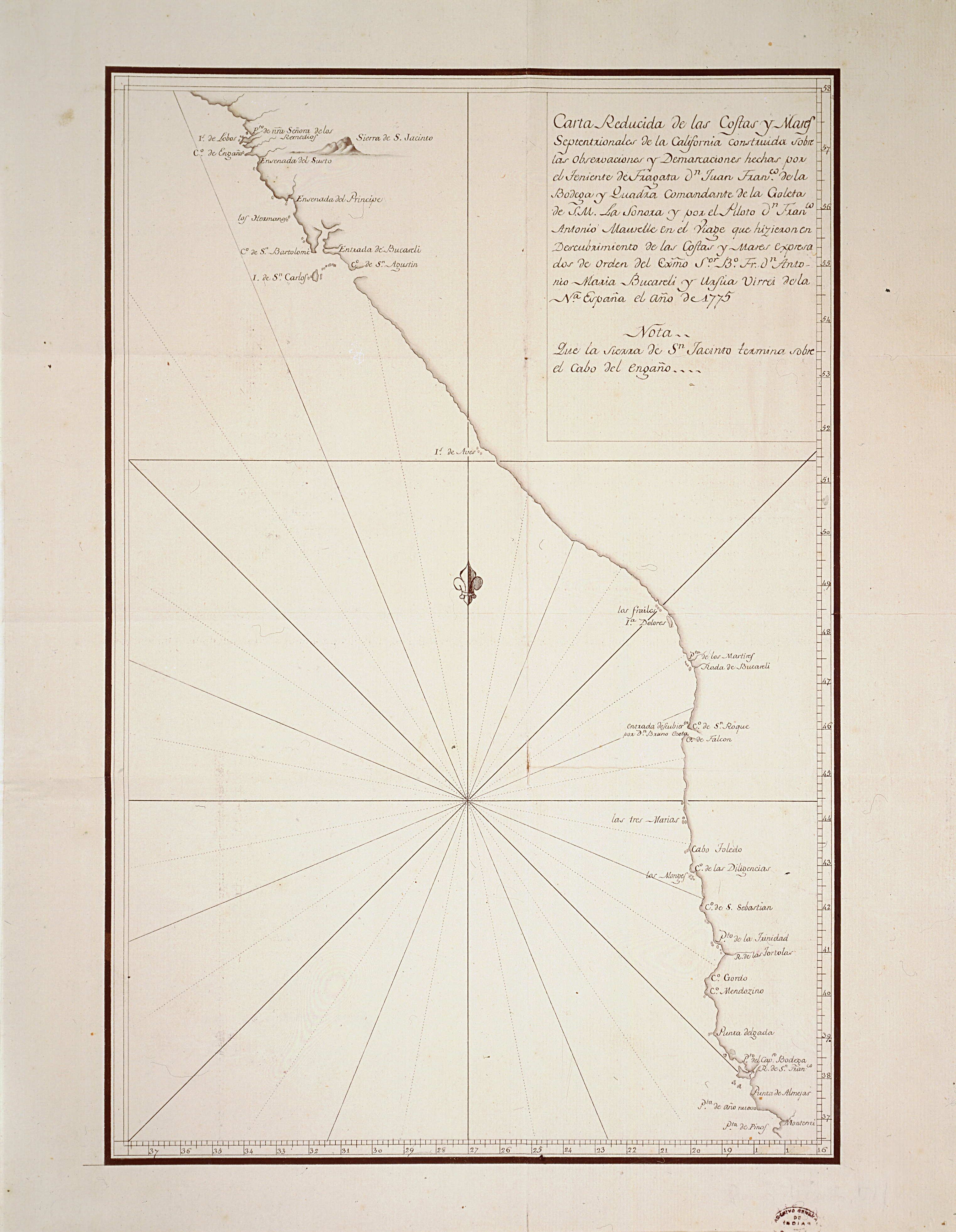
FIGURE 8. Carta Reducida de las Costas y Mares Septentrionales de la California construida sobre las observaciones y demarcaciones hechas por el teniente de fragata Don Juan Francisco de la Bodega y Quadra ( ..) 1775. [One of the first maps of the US West Coast from 36 to 58 degrees].[27]
- Technician in charge of the expedition course. ↵
- MECD, AGI, Estado 20, N.13. ↵
- AGI, Estado 38A, N.11. ↵
- AGI, Estado 38A, N.5. ↵
- AGI, Estado 38A, N.4. ↵
- AGI, Guadalajara 515, N.44. ↵
- AGI, Estado 38A, N.6 a N.9. ↵
- AGI, MP-México 306 a 309, 531 y 581 a 584. ↵
- MECD, AGI, Estado 38A, N.11. ↵
- Bison ↵
- MECD, AGI, Estado 38A, N.11. ↵
- Ibid. ↵
- Ministerio de Educación Cultura y Deporte, AGI, Estado 38A, N.11, image #25 (folio 13r). Accompanies: Estados de navegación, 1775. // [Copy of the Navigation Diary Made by Lieutenant Don Bruno de Hezeta on the Frigate Santiago, Alias Nueva Galicia, which went to the Discoveries of the Northern Coasts of California from the Department of San Blas, from March 16th to November 20th, 1775]. ↵
- Ibid. ↵
- Reid, Joshua L. The Sea is my Country: The Maritime World of the Makahs, edit. Yale University Press, 2015. ↵
- Ministerio de Educación Cultura y Deporte, AGI, MP-México 306. // [Map of La Asunción Bay, or Entrada de Heceta, between the San Roque and Frondoso Capes, on the Coast of the Pacific Northwest, Corresponding to the Reconnaissance Expedition Made in 1775 by Ship Lieutenant Bruno De Heceta y Dudagoitia, by Order of Antonio María De Bucareli y Ursúa, Viceroy of New Spain, 1775]. ↵
- MECD, AGI, Guadalajara 515, N.44. ↵
- Ibid. ↵
- MECD, AGI, Guadalajara 515, N.44. ↵
- Ibid. ↵
- Ibid. ↵
- Ibid. ↵
- Ibid. ↵
- Ibid. ↵
- All this was the territory of the Miwok coast, whose inhabitants were also called Mokelumni, Mewuk, or Meewok, terms that mean “people” or “men.” It seems that their linguistic group was from the Utinas language family, called Miwok-Costanoano and that their traditional territory was located in the Sierra Nevada and on the shores of the San Joaquín River, where they lived in several different groups. The Miwok with whom De la Bodega y Cuadra made contact could be from the Helapattai, Himetakala, Ho-takala or Tokau villages, since they were all people who inhabited the bay that he named Bodega. Although if we take into account that it was not really there where they anchored, but instead they anchored at a nearby bay named Tomales, perhaps the Miwok tribe or village with which he had contact with was that of the Utumia. ↵
- AGI, State 20, N.18 to N.24. ↵
- Ministerio de Educación Cultura y Deporte, AGI, MP-México 581. // [Reduced Chart of the Northern Coasts and Seas of California Built on the Observations and Demarcations Made by Lieutenant Don Juan Francisco de la Bodega y Quadra (...) 1775]. ↵
