
13.2 Landforms and Coastal Erosion
Large waves crashing onto a shore bring a tremendous amount of energy that has a significant eroding effect. Several unique erosion features commonly form on rocky shores with strong waves.
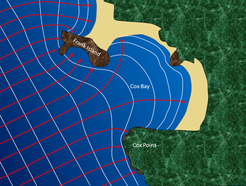
When waves approach an irregular shore, they are slowed down to varying degrees, depending on differences in the water depth, and as they slow, they are bent or refracted. In Figure 13.12, wave energy is represented by the red arrows. That energy is evenly spaced out in the deep water, but because of refraction, the energy of the waves—which moves perpendicular to the wave crests—is being focused on the headlands (Frank Island and Cox Point in this case). On irregular coasts, the headlands receive much more wave energy than the intervening bays, and thus they are more strongly eroded. The result of this is coastal straightening. An irregular coast, like the west coast of Vancouver Island, will eventually become straightened, although that process will take millions of years.
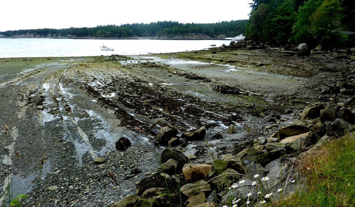
Wave erosion is greatest in the surf zone, where the wave base is impinging strongly on the sea floor and where the waves are breaking. The result is that the substrate in the surf zone is typically eroded to a flat surface known as a wave-cut platform (or wave-cut terrace) (Figure 13.13). A wave-cut platform typically extends across the intertidal zone.
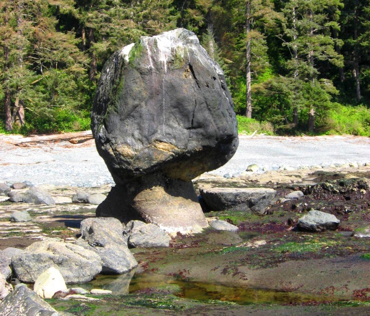
Relatively resistant rock that does not get completely eroded during the formation of a wave-cut platform will remain behind to form a stack. An example from the Juan de Fuca Trail of southwestern Vancouver Island is shown in Figure 13.14. Here the different layers of the sedimentary rock have different resistance to erosion. The upper part of this stack is made up of rock that resisted erosion, and that rock has protected a small pedestal of underlying softer rock. The softer rock will eventually be eroded and the big rock will become just another boulder on the beach. Note that this is a somewhat unique situation. Most stacks do not show that nature of differential erosion.
Arches and sea caves are related to stacks because they all form as a result of the erosion of relatively non-resistant rock.
The following photographs show the demise of Jump-Off Joe, a one-hundred-foot-high sandstone formation known as a “sea stack” in coastal Oregon. In 1890, the sea stack was composed of middle Miocene concretionary sandstone of the Astoria Formation. Yaquina Head on the Horizon is composed of middle Miocene basalt flows and breccia. Note remnant of Pleistocene terrace deposit along the wave cut bench on the stack. Jump-Off Joe was a well-known tourist attraction, but it weathered rapidly. Its arch collapsed in 1916, a few years after the last black-and-white photo, shown below, was taken. There is nothing left of Jump-Off Joe today.


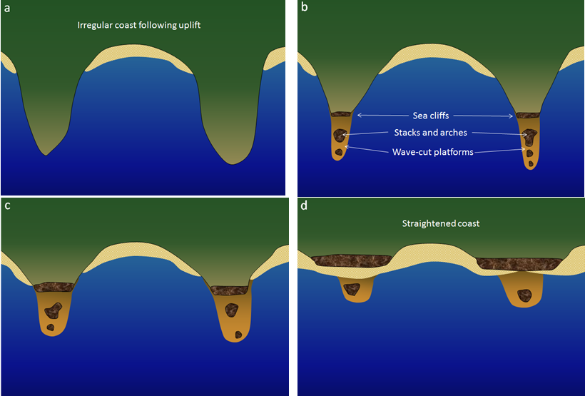
Figure 13.18 summarizes the process of transformation of an irregular coast, initially produced by tectonic uplift, into a straightened coast with sea cliffs (wave-eroded escarpments) and the remnants of stacks, arches, and wave-cut platforms. The next stages of this process would be the continued landward erosion of the sea cliffs and the complete erosion of the stacks and wave-cut platforms in favor of a continuous nearly straight coast. That straight coast might be a sea cliff, or—if there is a sufficient and ongoing source of sand—a beach
Media Attributions
- Figures 13.12, 13.13, 13.14: © Steven Earle. CC BY.
Licenses and Attributions
“Physical Geology – 2nd Edition” by Steven Earle is licensed under CC BY 4.0 Adaptation: Renumbering, Remixing
a point extending out to sea
the tendency for an irregular coast to be straightened over time by coastal erosion processes
a nearly-horizontal bench of rock eroded by waves within the surf zone (equivalent to wave-cut terrace)
a prominent rocky island that is a remnant of the erosion of a headland
a rock weathering remnant in the form of an arch (typically along a coast and resulting from wave erosion)
a shallow cave formed on a rocky shore by wave erosion
a coastal escarpment that is typically eroding inland as a result of wave action
