
Chapter 12 Answers
Review Question Answers:
- The Cryogenian glaciations are called Snowball Earth because it is thought that freezing conditions affected the entire planet and that the oceans were frozen over, even at the equator.
- The cooling from the end of the Paleocene until the Holocene was related to the formation of mountains including the Himalayas, the Rockies, and the Andes; the opening of the Drake Passage; the development of Antarctic Circumpolar Current; and the closing of the Isthmus of Panama.
- The first glaciation of the Cenozoic took place in Antarctica during the Oligocene (around 30 Ma).
- At the height of the last glaciation, the Laurentide Ice Sheet covered almost all of Canada and extended south into the United States as far as Wisconsin.
- Continental glaciers flow from the areas where the ice is thickest (and therefore at the highest elevation) toward areas (at the margins) where the ice is thinnest. Ice thickness tends to be related to the rate of ice accumulation.
- The equilibrium line represents the boundary between the area where ice is accumulating (typically at high elevations), and where it is being depleted (mostly by melting). Above the equilibrium line more snow accumulates in winter than can melt in summer so the glacier is always covered in snow. Below the equilibrium line the snow cover is lost by the end of summer.
- Relatively cool summers are more important because that controls how much snow will melt in the summer. In many situations very cold winters are associated with less snow accumulation than just cold winters.
- The ice at the bottom of a glacier flows more slowly than that at the top. In fact if the glacier is frozen to its base the lowermost ice might not be moving at all.
- The edges also flow more slowly than the middle because there is more friction there between the ice and the valley walls.
- Basal sliding will take place when the bed of the glacier is warm enough for water to be liquid. The water will act as a lubricant to allow the ice to flow.
- Glaciers carve U-shaped valleys because they are relatively wide (compared with rivers) and most of the erosion takes place at the base rather than the sides. A hanging valley forms where a tributary glacier joins a larger glacier and where the larger glacier has eroded a deeper valley.
- There must be at least three cirques to form a horn. In most cases there wouldn’t be room for more than four.
- A drumlin is relatively steep at the up-ice end and streamlined at the down-ice end. A roche moutonée is streamlined at the up-ice end and jagged at the down-ice end where plucking has taken place.
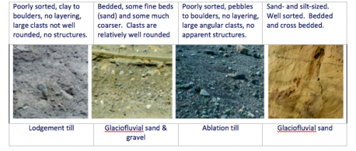
- Lodgement till are poorly sorted, clay to bounders, with no layering and large clasts that are not well-rounded, and has no structures. Glaciofluvial sand and gravel are bedded with some fine beds (sands) and some much coarser grains. Clasts are relatively well-rounded. Ablation till are poorly sorted with pebble to boulder sized clasts, no layering and large angular clasts and no apparent structures. Glaciofluvial sand has sand and silt-sized grains, is well-sorted, with beds and cross-bedding.
- Drop stones are large clasts that are present with lacustrine or marine glacial sediments. They form when coarse material drops from melting icebergs.
- Glaciofluvial sediments (sand or sand and gravel) are likely to be sufficiently permeable to make good aquifers.
Exercise Answers:
Exercise 12.1 Pleistocene glacials and interglacials
Describe the nature of temperature change that followed each of these glacial periods.
In each case the temperature drops slowly building to a peak of glaciation, and then each of the glacial periods is followed by a very rapid increase in temperature.
The current interglacial (Holocene) is marked with an H. Point out the previous five interglacial periods.
The previous 5 interglacials are labelled 1 to 5 on the diagram below. Interglacial 2 had two distinct warm episodes.
![[SE]](https://opentextbc.ca/physicalgeology2ed/wp-content/uploads/sites/298/2019/08/ex16-1-300x178.png)
[Image by Steven Earle] Exercise 12.2 Ice advance and retreat
![Glacial advance (top) and retreat (bottom) [SE]](https://opentextbc.ca/physicalgeology2ed/wp-content/uploads/sites/298/2019/08/ex16-2-300x150.png)
Glacial advance (top) and retreat (bottom) [Image by Steven Earle] The red dots show the new positions of the markers.
Exercise 12.3 Identify glacial erosion features
- col
- arête
- horn
- cirque
- truncated spur (other arêtes are labelled in the image)
![[SE after http://en.wikipedia.org/wiki/Mount_Assiniboine#/media/File:Mount_Assiniboine_Sunburst_Lake.jpg]](https://opentextbc.ca/physicalgeology2ed/wp-content/uploads/sites/298/2019/08/ex16-3-300x185.png)
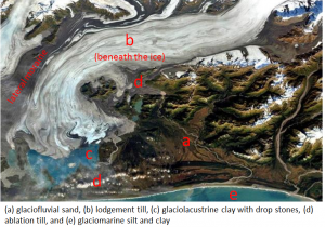
[Image by Steven Earle after http://en.wikipedia.org/wiki/Mount_Assiniboine#/media/File:Mount_Assiniboine_Sunburst_Lake.jpg] Exercise 12.4 Identify glacial depositional environments
[Image by Steven Earle after USGS at http://water.usgs.gov/edu/gallery/glacier-satellite.html Licenses and Attributions
“Physical Geology – 2nd Edition” by Steven Earle is licensed under CC BY 4.0 Adaptation: Renumbering, Remixing

![[SE]](https://opentextbc.ca/physicalgeologyearle/wp-content/uploads/sites/145/2016/07/ex16-1.png)
![Glacial advance (top) and retreat (bottom) [SE]](https://opentextbc.ca/physicalgeologyearle/wp-content/uploads/sites/145/2016/07/ex16-2.png)
![[SE after http://en.wikipedia.org/wiki/Mount_Assiniboine#/media/File:Mount_Assiniboine_Sunburst_Lake.jpg]](https://opentextbc.ca/physicalgeologyearle/wp-content/uploads/sites/145/2016/07/ex16-3.png)

