8.6 Volcanic Hazards
The basaltic lava flows produced by volcanoes on the island of Hawai’i are responsible for extensive damage to homes, infrastructure, and habitats. Figure 8.38 shows lava flows (in black) from the Puʻu ʻŌʻō crater of Kīlauea Volcano. The lava flow destroyed the house, and is encroaching on the transfer station. Smoke in the background marks locations where additional flows have broken out and are burning vegetation.

In spite of the damage that lava flows can cause, they are not the volcanic hazard with the greatest impact on lives and infrastructure. Even the relatively free-flowing Hawai’ian basaltic lava moves slowly enough that it can be escaped on foot. Far more dangerous hazards are related to gases and volcanic debris. However, the largest impact and the greatest suffering are caused not by the immediate effects of volcanic eruptions, but by large-scale changes to climate and environments caused by volcanism. Indirect effects resulting in respiratory distress, toxicity, famine, and habitat destruction have accounted for approximately 8 million deaths during historical times, while direct effects have accounted for fewer than 200,000, or 2.5% of the total.
Volcanic Gas and Tephra Emissions
Large volumes of rock and gases are emitted during major Plinian eruptions at composite volcanoes, and a large volume of gas is released during some very high-volume effusive eruptions. Gases and fine particles of volcanic ash can cause respiratory distress and poisoning, and ash poses a risk for aircraft.
Most of the tephra from large explosive eruptions ascends high into the atmosphere, and some of it is distributed around Earth by high-altitude winds. The larger components (larger than 0.1 mm) fall closer to the volcano, and the accumulation of tephra from large eruptions can cause serious damage and casualties. When the large eruption of Mt. Pinatubo in the Philippines occurred in 1991, tens of centimeters of ash accumulated in fields and on rooftops in the surrounding populated region. Heavy typhoon rains hit the island at the same time and added to the weight of the tephra. The weight was too much for roofs to bear, and thousands of structures collapsed, causing at least 300 of the 700 deaths attributed to the eruption.
One of the long-term effects of adding volcanic particles and gases to the atmosphere is cooling. Over an eight-month period in 1783 and 1784, a massive effusive eruption took place at the Laki volcano in Iceland. Although there was relatively little volcanic ash involved, a massive amount of sulphur dioxide was released into the atmosphere, along with a significant volume of hydrofluoric acid (HF). The sulphur dioxide combined with water to make sulphate aerosols, which block incoming solar energy. The accumulation of sulphate aerosols over that 8 months led to dramatic cooling in the northern hemisphere. There were serious crop failures in Europe and North America, and a total of 6 million people are estimated to have died from famine and respiratory complications. In Iceland, poisoning from the HF resulted in the death of 80% of sheep, and 50% of cattle. The ensuing famine, along with HF poisoning, resulted in more than 10,000 human deaths, about 25% of the population.
Pyroclastic Flows
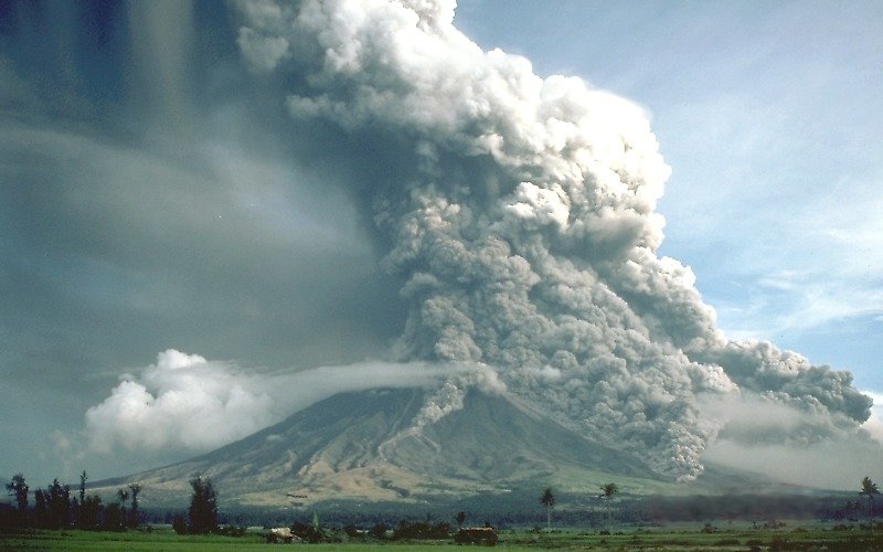
In a typical explosive eruption at a composite volcano, the tephra and gases are ejected with explosive force and sent high up into the atmosphere. As the eruption proceeds, and the amount of gas in the rising magma starts to decrease, and less gas is supplied to the eruption column. Parts of the column will become denser than air, leading the column to collapse and flow downward along the flanks of the volcano (Figure 8.39), picking up speed as it cools.

Pyroclastic flows can travel over water, in some cases for many kilometers. In 1902 the pyroclastic flow from the eruption of Mt. Pelée traveled out into the harbour and destroyed several wooden ships anchored there. The pyroclastic flow from the 1883 eruption of Krakatau traveled 80 km across the Sunda Straits and claimed victims on the southwest coast of Sumatra. It also triggered a tsunami.
One of the most famous pyroclastic flows occurred when Mt. Vesuvius erupted in 79 CE. It buried the cities of Pompeii and Herculaneum, killing an estimated 18,000 people.
Lahar
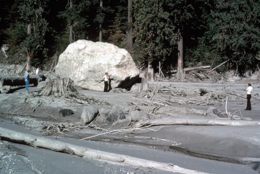
A lahar is any mudflow or debris flow that is related to a volcano (Figure 8.40). Most are caused by melting snow and ice during an eruption, as was the case with the lahar that destroyed the Colombian town of Armero in 1985 when the volcano Nevado del Ruiz caused the ice dam on a glacial lake to fail. The resulting lahar killed 23,000 in Armero, about 50 km from the volcano.

Lahars can also happen when there is no volcanic eruption, because composite volcanoes tend to be weak and easily eroded. In October 1998, category 5 hurricane Mitch slammed into the coast of Central America. Damage was extensive and 19,000 people died. Fatalities were largely because of mudflows and debris flows triggered by intense rainfall — some regions received almost 2 m of rain over a few days.
At Casita Volcano in Nicaragua, the heavy rains weakened rock and volcanic debris on the upper slopes, resulting in a debris flow that rapidly built in volume as it raced down the steep slope. It struck the towns of El Porvenir and Rolando Rodriguez killing more than 2,000 people. El Porvenir and Rolando Rodriguez were new towns that had been built without planning approval in an area that was known to be at risk of lahars.
Sector Collapse and Debris Avalanche
In the context of volcanoes, sector collapse or flank collapse is the catastrophic failure of a significant part of an existing volcano, creating a large debris avalanche. This hazard was first recognized with the failure of the north side of Mt. St. Helens immediately prior to the large eruption on May 18, 1980.
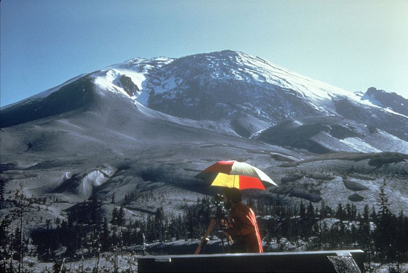
In the weeks before the eruption, a large bulge had formed on the side of the volcano (Figure 8.41) as magma moved from depth into a magma chamber within the mountain itself. Early on the morning of May 18, a moderate earthquake struck and destabilized the bulge, leading to Earth’s largest observed landslide in historical times. The failure of this part of the volcano exposed the underlying magma chamber, causing it to explode sideways. This in turn exposed the conduit leading to the magma chamber below, resulting in a Plinian eruption lasting nine hours.

Video: Geoscience Videos – What are Volcanic Hazards
Licenses and Attributions
“Physical Geology, First University of Saskatchewan Edition” by Karla Panchuk is licensed under CC BY-NC-SA 4.0 Adaptation: Renumbering, Remixing

